Gps 12
Advertisement
TN Complete v.2 8
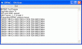
TN Complete shows the route flown, the barogram of the flight (including vario and TAS [1]), it gives the flight stats and a temperature curve for the flight.
Advertisement
MarshallSoft GPS Component for C/C++ v.2.2
GPS NMEA component C++ and .NET library reads and decodes standard GPS NMEA 183 sentences from the RS232 serial port; computes great circle distances and bearings. Runs as a background thread unattended. Works with C/C++,Visual Studio,C++ Builder.

MarshallSoft GPS Component for VB v.2.2
GPS NMEA component Visual Basic and .NET library reads and decodes standard GPS NMEA 183 sentences from the RS232 serial port; computes great circle distances and bearings. Runs as a background thread unattended. Works with Visual Basic and VB.NET.
Eye4Software GPS Toolkit
Toolkit to add GPS functionality to software (GPS SDK). All NMEA0183 protocol versions are supported, all NMEA 0183 can be filtered by NMEA type and talker ID. Information on GPS status can also be retrieved: GPS fix quality, Satellites used in fix, DGPS

Icons-Land Vista Style GIS/GPS/MAP Icon Set v.2.0
Vista Style GIS/GPS/Map Icon Set is of perfect design quality. Being represented in 7 sizes, icons can be widely used in local service applications, GPS tracking and GIS applications, and any kind of mapping applications.
Gps review
http://www.reviewsgps.us - Most were way too technical for me! Now, please understand, I'm very comfortable with technical devices. I currently teach mathematics and computer programming. It's just that it's hard to decide if a certain model GPS device is
GPS to vCard
With this tool you can add GPS coordinates to vCards - elektronic business cards - that you have previously exported from e. g. Microsoft Outlook. Therefore the tool uses the address data contained within the vCards and adds the exact GPS position on that

GPS Simulator v.1.0
GPS Simulator is software that generates a virtual GPS data, Used to develop and simulation of GPS applications, Save testing and development time, No location restriction or work everywhere, No GPS device needed
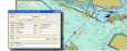
Eye4Software GPS Mapping Studio v.4.1
GPS Mapping Software for Windows, Loading topographic maps, Realtime navigation, GPS position tracking, Map import and export, Coordinate conversion and more
F14 ops on CV69-12 v.1.0.6
FSX Mission--F-14 Ops On CV69-12. Start off in Dino Cattaneo's F-14 Tomcat on Javiers (Thrawns) CV69-12 Busy Carrier. Five Tomcats will be flying patterns and landing. Fly in free flight mode or fly the quick mission.
GPS TrackMaker PRO v.11.8.0.183
The professional version of GPS TrackMaker® is for those users that need area calculation, data transfer to Microsoft Excel®, import and export to AutoCad® and ArcView®, and other advanced functions.